The day begins somehow in mellow fashion, as we know we have lots of fun downhill sections and some modest climbs on the 56km to Xiaojin. We are already in the Tibet Kham region, also known as East Tibet. Mao borrowed a lot of his evil ideas from the European imperialist and his buddy Stalin, so when he decided to create “Tibet”, he took away large chunks of it and put it in the neighboring provinces. This way northwestern Yunnan, Western Sichuan, Gansu and pretty much all Qinghai (except maybe Xining area) are in fact Tibet. It is famously difficult to escape the complicated and pricey bureaucracy and get independent visa to cycle the Autonomous Region proper, so we have decided to come here. The Kham are culturally related to, even if not exactly identical to the Tibetans in Lhasa’s country. This part of China is completely new to us.
Tibetans love to settle in deep gorges or on high grasslands and mountain passes, places where autumn should be a great time to visit. Once out of Rilong, their typical stone houses (diaofang) start popping.


Built from stone and wood or simply rammed earth, their walls may be up to a meter thick at the base and sloping inward to create an illusion of height. These are proper fortresses with prominent roof corners, impenetrable by wind, cold or thieves. The intricate carvings and paintings at bays and openings ensure that the house remains also untouched by evil spirits. The ground floor is inhabited by the herd of the family, who lives upstairs.
Architecture in Tibet Kham and Tibet proper adapted Chinese and Indian influences to the harsh climate of a high-altitude plateau. The simplicity of dwellings reminds us of rural Mongolia. Even if they had to make do with limited resources, the Tibetans, just like the Mongols, love to embellish their homes with Buddhist auspicious symbols. One of the most prominent is the Endless or the Mystical Knot. It is depicted as overlapping, suggesting no beginning and no end. As a religious symbol, it represents the Buddha’s endless wisdom and compassion. But it can also be placed on gifts and other objects as a secular symbol of interconnectivity and love, and an invitation to begin or to deepen a personal relationship.
The Himalayas and the Tibetan mountains were ocean floors so the ancient conch shells that have been found here are now an emblem of power, authority and sovereignty. Ancient Indian and Tibetan epics bestow the conch with magical powers in averting natural disasters, scaring away poisonous creatures and even banishing evil spirits. Tibetans favour the right-turning conch shell, believed to be the indispensable amulet of warriors. The right spiralling movement echoes the celestial motion of the sun, the moon, the planets and the stars across the heavens, therefore even Buddha himself is depicted in temples with the hair on his head turning to the right.


A symbol in use within many cultures for over 3,000 years, only to be discredited by the Nazis, also makes an appearance in Tibet Kham. Here the clockwise swastika still means life, sun, power, strength, and good luck. Actually the word comes from the Sanskrit svastika – “su” meaning “good,” “asti” meaning “to be,” and “ka” as a suffix.
7km down we are in front of the entrance for Mt. Siguniangshan Scenic Area, the big attraction of the Rilong area. The government has been boosting tourism to such places. They were rebranded as AAAAA class destinations (or some number of ‘A’s, the more, the better). Nearby Four Girls Mountain and Shuangqiao Valley get predominantly Chinese visitors. We are the only laowai at the gates and we realise that it is strictly hiking into the park and no bicycles are permitted.


We have already climbed down to 3K. The signpost is a sad reminder of the Panda Research Centre that used to be in Wolong. The 5.12 earthquake largely destroyed the reserve and the pandas had to be moved.
We are skirting the Dawei River. The mid-morning air is brisk. Our bodies fuelled with the buttermilk and our heart rates sufficiently jumpy from the caffeine, we make nice progress.


To our help, road conditions are great, so thinks our only companion, the yak.


Occasionally we get to switch to lower gear and climb to the top of a hill where a village lies. Wherever there are signs of life, we see peasants loading trucks and carriages with fruit. This valley is famous for its apples. I’d say it should be famous for its people also. As soon as I emerge into the village, breathing in sharply and red-faced, the villagers insist I should rest with them with an apple in hand. It is fragrant and crunchy, which makes me question why the apples sold in Ulaanbaatar, even the ridiculously expensive ones, were so bland.


At Menggu bridge a huge white stupa sits on the road junction.
The Tibetan stupas, also called Chörtens, are religious structures distinct from temples and used as reliquaries. They are round in Kham, and four-sided in India, Nepal and Pakistan, we hear.


There is an old chain bridge still spanning the river, but no longer in use. Even so, as all perilous water or mountain crossings, it has Buddhist prayer flags flying from the top.


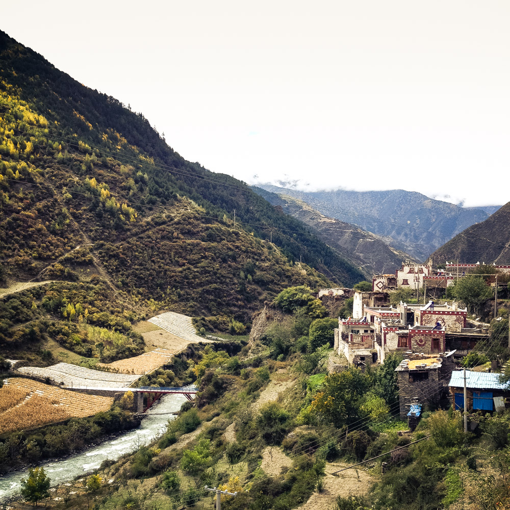
Our tourist agenda through Tibet Kham… well, we have intentionally left it to hazard. Therefore surprises like the tower of Wori Township, rising on the left across the river at 35 km after Siguniangshan, are the more enjoyable. We’ll take a closer look.


A board informs that the village was partly rebuilt after the earthquake. The recent works haven’t diminished its charm and there are touching signs of local spirit everywhere. From up the hill there’s a nice view of the cornfields stretched along the water.


A bus of Taiwanese people arrives at the same time with us and we mingle. These people are all smiles. We must visit Taiwan someday.


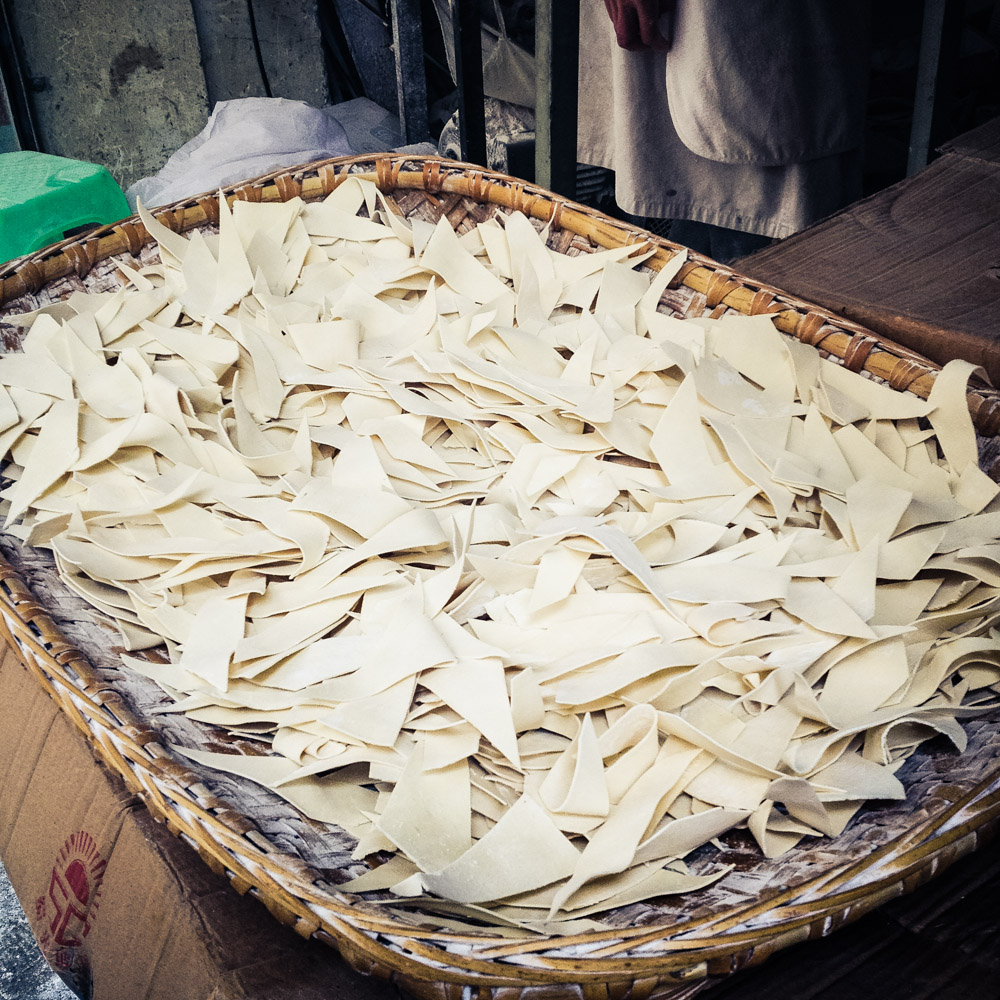
At noon we roll into a village and we park as soon as we detect the scent of food. We are not in fabled foodie heaven of Si Chuan, but sweating our way up the rustic Tibet Kham country, yet this humble restaurant is serving some of the best stuff we’ve ever had. A husband and wife are running the tiny kitchen and we order both dishes on offer, essentially a noodle soup and dumplings. Both particularly amazing.
After following the bottom of the gorge, the smooth road climbs through the fairly large town of Xiaojin. While we scout for a guesthouse it starts raining. Ten Mandarin words round out my vocabulary so it takes a good hour to find a place. After being offered a room in an apartment with no key and a bed in what looked like a bordello, I see a lady walking into an alley with the hotel sign on top. I manage to explain to her that we are looking for a room and she ends up renting out their reception. She is a Han Chinese, and we are offered the usual thermos of hot water to drink.


As soon as the rain subsides, we go for a stroll around town.


Across our street there is family labouring away at their noodle shop. As you can see nothing is wasted.


A bakery was the last thing we’d imagine in a place like this. Everything, from buttery cookies to expanded rice and millet power-bars, is freshly handmade.

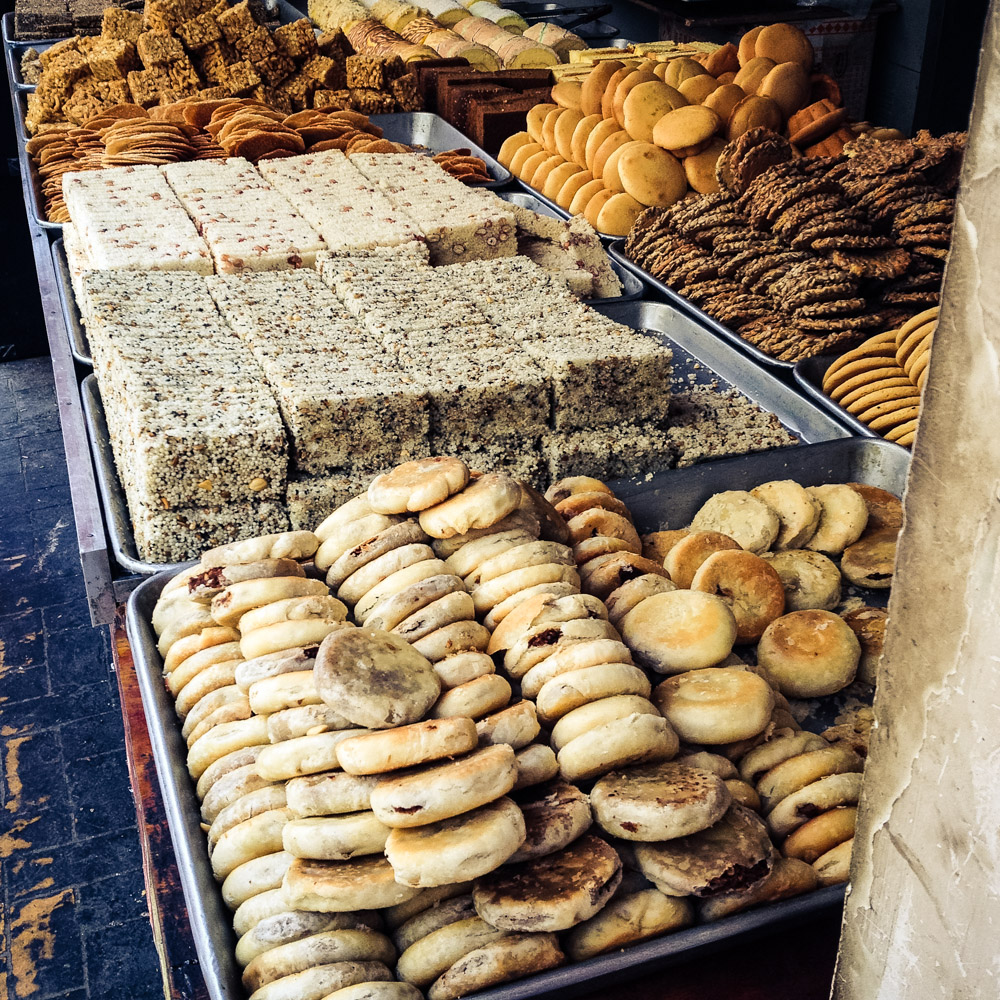
Starting with the following day we’ll make a habit of mid-morning breaks, dedicated to a cuppa and a sweet treat. After avoiding the calories throughout the Silk Road, we relish the fact that cycling eventually depletes you of energy and requires regular carb reloads.


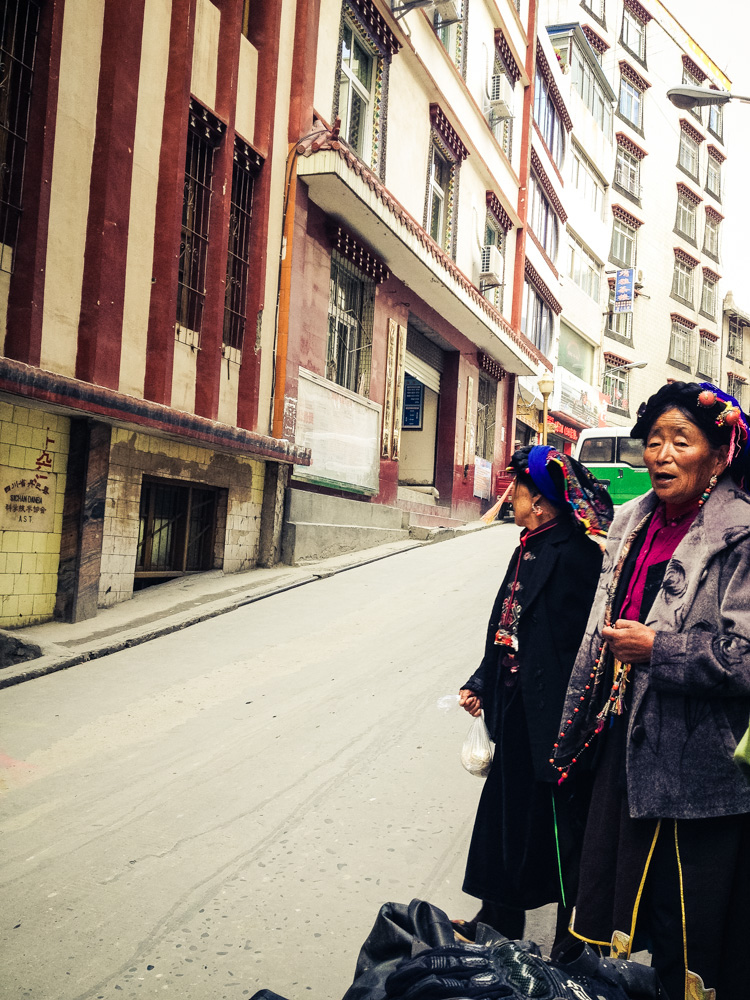
Duly refuelled we continue our ride with a more uphill trend. We can see there will be trouble finding a place to camp again, as all the flat land is utilised. But there are only 59km to go to Dan Ba (1893m altitude). About halfway there’s a turnoff on the left for a mountain road to Ya’an; we’ve been told that this is a good ride to close the loop back to Chengdu and that it is paved, except near the pass. Dan Ba sits on a terrace high above the muddy Da Du river. We arrive at noon on deceivingly fair weather. Meanwhile our fingers have turned purple from cold. We had the GPS coordinates for a hostel and its my job to negotiate a bed. The girl in the lobby listens to my sign language and giggles at my sketch, then makes me squeeze a tube of toothpaste and nods. I have no idea what that’s supposed to mean and I laugh on my way out of what couldn’t possibly be a hostel. I fail a couple more times, resorting to ask in Rom-glish the Tibetan ladies. Check out how steep is the road!

I see keys on strings but I am denied entry, possibly because some hotel owners haven’t received the memo: since recently tourists are no longer forbidden to check in. We stop for lunch in another family-owned little resto. The owners send us to the backpackers up the road where the receptionist is fluent in English. The rest of the day is for soaking in the vibe.


This county, which is under the administration of the Garze Tibetan Autonomous Prefecture is nicknamed the “Valley of Beauties”, because the local Qiang ethnic minority’s fairer complexion and delicate features. The local beauties wear a genuine or fake braid on top of a velvet head-wrap and lots of handmade earrings, necklaces, and hairpins. What we find unique is the fuchsia wool braided into the hair.


Most women wear embroidered aprons on top of their simple dark clothing.


As elsewhere in hard-working communities, the rearing of children and most household chores lay on the shoulders of women who carry toddlers in wraps or even bamboo baskets. If you squint, you can see in there one of those tantalising Tibetan (!) bakeries.


Men wear less conspicuous garb. Except for monks.


The little ones, on the other hand, are clearly students under a communist regime. It’s hard to believe we were once wearing the same scarlet scarves. Their penchant for action heroes is another thing we have in common. The uniform is completed with an arm scarf.


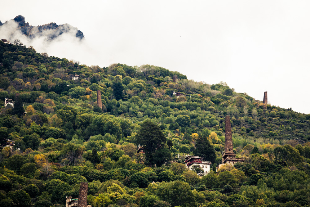
Lacking a written script and speaking a language from the Tibetan-Myanmese family, the Qiangs have only recently been recognised as a ‘first ancestor’ culture. They used to be nomadic, but have long settled as mountain dwellers and skilled masons. There are over 80 Qiang stone towers scattered throughout the region. From the Rilong-Danba T-junction we head south 3km and turn left on a dirt track invaded by thorn bushes and follow it to the picturesque Suopo village. The Qiang towers of Tibet Kham remind us of the Svan region of Georgia, and they must have had a similar storage as well as defense purpose.


By evening we are back from our 22km joyride and dine at the same restaurant as yesterday, then it’s time to leave Dan Ba behind. I enjoyed a lot the ride up to here. But this was just the calm before a topographical storm.

